


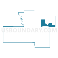
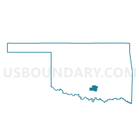
Voting District 18, Murray County, Oklahoma
About
Outline

Summary
| Unique Area Identifier | 654473 |
| Name | Voting District 18 |
| County | Murray County |
| State | Oklahoma |
| Area (square miles) | 15.35 |
| Land Area (square miles) | 15.16 |
| Water Area (square miles) | 0.19 |
| % of Land Area | 98.79 |
| % of Water Area | 1.21 |
| Latitude of the Internal Point | 34.52052600 |
| Longtitude of the Internal Point | -96.87932950 |
Maps

Graphs
Select a template below for downloading or customizing gragh for Voting District 18, Murray County, Oklahoma


Neighbors
Neighoring Voting District (by Name) Neighboring Voting District on the Map
- Voting District 10, Murray County, OK
- Voting District 15, Murray County, OK
- Voting District 17, Murray County, OK
- Voting District 20, Murray County, OK
- Voting District 63, Pontotoc County, OK
- Voting District 8, Johnston County, OK
- Voting District 9, Murray County, OK
Top 10 Neighboring County Subdivision (by Population) Neighboring County Subdivision on the Map
- East Murray CCD, Murray County, OK (8,175)
- Tishomingo CCD, Johnston County, OK (5,178)
- West Johnston CCD, Johnston County, OK (2,700)
- Southwest Pontotoc CCD, Pontotoc County, OK (1,443)
Top 10 Neighboring Place (by Population) Neighboring Place on the Map
Top 10 Neighboring Unified School District (by Population) Neighboring Unified School District on the Map
- Sulphur Public Schools, OK (7,942)
- Roff Public Schools, OK (1,706)
- Mill Creek Public Schools, OK (913)
Top 10 Neighboring State Legislative District Lower Chamber (by Population) Neighboring State Legislative District Lower Chamber on the Map
Top 10 Neighboring State Legislative District Upper Chamber (by Population) Neighboring State Legislative District Upper Chamber on the Map
- State Senate District 6, OK (79,973)
- State Senate District 14, OK (76,649)
- State Senate District 13, OK (73,191)
Top 10 Neighboring 111th Congressional District (by Population) Neighboring 111th Congressional District on the Map
Top 10 Neighboring Census Tract (by Population) Neighboring Census Tract on the Map
- Census Tract 7908, Murray County, OK (6,140)
- Census Tract 6602, Johnston County, OK (5,178)
- Census Tract 6603, Johnston County, OK (2,700)
- Census Tract 896, Pontotoc County, OK (2,117)
- Census Tract 7906, Murray County, OK (2,035)